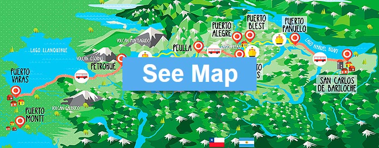
DISTANCIAS
|
|
|
||||||||||||||||||||||||||||||||||||||||||
|
|
 PUERTO VARAS
  BARILOCHE
PUERTO VARAS
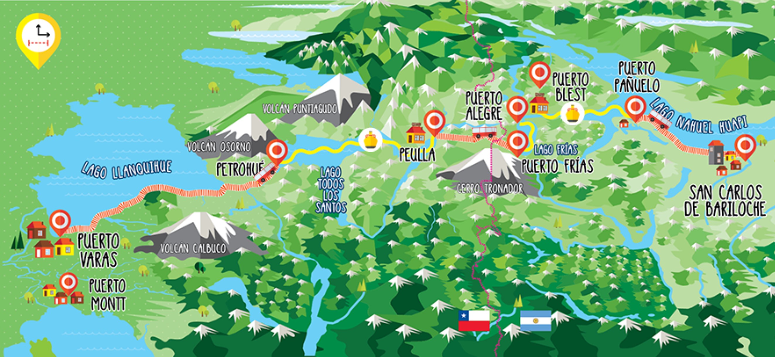
The tourist capital of southern Chile, Puerto Varas is located on the shores of Lake Llanquihue and offers easy access to the region mountains, forests and national parks. Settled by German immigrants, the city exudes an unmistakable Alpine vibe. Also called the City of Roses, Puerto Varas was chosen as one of the best cities to live in Chile.

PETROHUÉ
This small waterfront village is the starting and ending point for trips across Lake Todos los Santos. On the outskirts of town, the Saltos del Petrohué of crystal clear green tinged water. Picture perfect, the falls are located in Vicente Pérez Rosales National Park with great views of Osorno Volcano in the background.

VILLA PEULLA
In Mapuche, “Peulla” means “spring sprouts”. Peulla is the base camp for Cruce Andino travelers who want to linger more than one day in the Andes, Natura Hotel, and take advantage of adventures available in the forests, mountains and Rio Negro river valley between Peulla and the Chile-Argentina border.

PUERTO FRÍAS
Located on the southern shore of Lago Frías, this remote Argentine outpost is both a ferry landing on the Cruce Andino route and the customs checkpoint between Chile and Argentina. The hamlet's main claim to fame was a 1952 visit by Ernesto “Che” Guevara and his friend Alberto Granado during a long-distance motorcycle trip immortalized in The Motorcycle Diaries.

PUERTO ALEGRE
It is a loading dock located in the north margin, which is connected by a road with Port Blest, which is approximately 3 km far from this small lakeside port.

PUERTO BLEST
Puerto Blest, Argentina, is the only other place besides Peulla where travelers on the Cruce Andino route can stay overnight and extend their Andes crossing. Located at the western end of Lake Nahuel Huapi inside the national park of the same name, the remote hamlet is home to the Hotel.

PUERTO PAÑUELO
It is a lakeside port for passengers, located in the middle of the route between Puerto Blest and Bariloche. It is exactly 25 kilometers far from Bariloche. This port was built in 1965 by the National Parks’ National Administration.

BARILOCHE
San Carlos de Bariloche is located on the southern shore of Lago Nahuel Huapi at the eastern end of the Cruce Andino route. The resort town is known for the excellent gastronomy and lots of activities for enjoy, in summer or winter.

LLANQUIHUE LAKE
The second largest freshwater body in Chile, this deep-blue lake boasts a surface area of around 330 sq miles. Located in the Los Lagos Region, its fan-like shape was caused by glacial retreat over thousands of years. Farmland and villages cover most of its western shore, while Osorono Volcano dominates the eastern side.

TODOS LOS SANTOS LAKE
Located within the boundaries of Vincente Pérez Rosales National Park. Todos los Santos was named by Jesuit missionaries who “discovered” the lake on All Saints Day of 1670. During the Cruce Andino catamaran cruise across the lake (which takes an hour and 45 minutes), travelers can marvel at passing waterfalls, three snowcapped peaks, and the surrounding evergreen forest.

LAGO FRÍAS
At Frías Lake, the navigation is short, only 15 minutes. Has an glacial origin and its main tributaries bring defrost water which colors the lake in turquoise.

LAGO NAHUEL HUAPI
The centerpiece of Argentina's Nahuel Huapi National Park is located 2,500 feet above sea level and covers some 200 square miles. The lake is the either the first or last water leg of the Cruce Andino crossing depending on which way you're traveling. The name Nahuel Huapi means "Island of the Puma" in the language of the indigenous Mapuche people.

CALBUCO VOLCANO
The altitude of this volcano is 2003 meters. Is located in the Region of Los Lagos, at the southeast of Llanquihue Lake. The last was April 30, 2015, and it is still active. Its silhouette is visible from the most important points of the region. It has been named as the town of Calbuco, which is nearb.

OSORNO VOLCANO
One of the iconic landmarks of Chilean Patagonia, Osorno is a perfectly conical, snowcapped stratovolcano on the eastern shore of Lake Llanquihue. Osorno is a great place to trek or ride the chair lift up the slope for panoramic views. The last volcanic activity recorded was 148 years ago.

PUNTIAGUDO VOLCANO
2490 meters above sea level volcano rises between the Rupanco and Todos los Santos lakes, bordering the Vicente Perez Rosales National Park. The last eruption was in 1850. At present, this volcano is in state of lethargy.

TRONADOR MOUNT
Tronador is the Spanish word for "thunder”, a name conferred on this majestic, 11,600-foot volcano due to the sounds emitted by its seven glaciers. The region's highest mountain sits astride the Chile-Argentina border and the boundary between Nahuel Huapi National Park in Argentina and Vicente Pérez Rosales Park in Chile.

ANDEAN LAKES CATAMARAN
Travelers can sail between Peulla and Petrohué ports through the Todos los Santos Lake, in a catamaran with a 308 passengers’ capacity. It has central heating, bar, cafeteria, closed circuit TV and a small souvenir shop.

VICTORIA DEL SUR CATAMARAN
This Catamaran navigates between Puerto Alegre and Puerto Frías, in Argentina. It has a 110 passengers’ capacity and has heating, audio, life rafts.

GRAN VICTORIA CATAMARAN
This Catamaran navigates between Puerto Pañuelo and Puerto Blest - in Argentina - and has a 255 passengers’ capacity. It holds high security and comfort standards on board, two decks for passengers, a large bar, 14 tables in its main hall with large windows.

NATURA HOTEL
Rustic hotel with modern facilities, but always respecting the style of the place. It is located in the center of Villa Peulla. It has 45 rooms overlooking to the nature, mountains and volcanoes.

HOTEL BLEST
Puerto Blest Hotel was founded in 1904 and was open to world travelers until 2009. After a renovation it reopened in 2015. The peculiar location and the surrounding Valdivian jungle environment make the Hotel Puerto Blest a must-see place.